Optimization Disaster Logistics by Determining the Optimal Location and Number of Evacuation Centers

Downloads
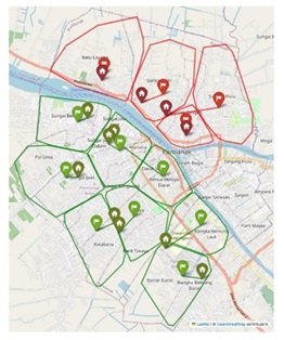
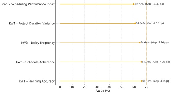
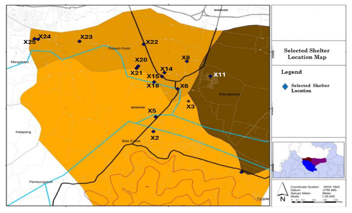
Indonesia, particularly Bandung Regency, faces significant flood risks that disrupt livelihoods and damage infrastructure. This study identifies the optimal locations and number of evacuation centers using the Set Covering Problem (SCP) model, integrating geographic data, population density, accessibility, and infrastructure capacity. The study applied constraints including a 1,000-meter maximum service distance, minimum road width of 6 meters for Class IIIB and IIIC access, shelter capacity limits, and full coverage of demand points. Using ArcGIS 10.2.1, candidate locations were evaluated by overlaying flood vulnerability maps with accessibility and facility data. Environmental sustainability was addressed by selecting sites with minimal ecological disruption, avoiding sensitive zones, and reusing existing structures to reduce land conversion. Results show that five centralized shelters in high-density, well-connected areas can cut evacuation travel time by up to 20% compared to dispersed locations. This integrated approach improves response efficiency, ensures access for vulnerable populations, and supports sustainable site planning. The findings contribute to disaster logistics theory and offer practical, replicable guidance for policy in other flood-prone regions.
Downloads
[1] Y. Veronica, Sutoyo, M. I. Rau, and C. Arif, “Range, capacity, and closest evacuation route analysis to tsunami evacuation shelter in Pandeglang Regency Banten Indonesia,” IOP Conference Series: Earth and Environmental Science, vol. 622, p. 012042, 2021, doi: https://doi.org/10.1088/1755-1315/622/1/012042.
[2] W. J. W. Botzen, O. Deschenes, and M. Sanders, “The Economic Impacts of Natural Disasters: A Review of Models and Empirical Studies,” Review of Environmental Economics and Policy, vol. 13, no. 2, pp. 167–188, 2019. doi: https://doi.org/10.1093/reep/rez004.
[3] Mathieu Deflem, “Introduction: Disasters and Hazards in Socio-Legal Studies,” Sociology of crime, law and deviance, pp. ix–xii, 2012, doi: https://doi.org/10.1108/s1521-6136(2012)0000017003.
[4] S. H. S. Herho, E. Riawan, C. Nugraha, R. Suwarman, I. D. G. A. Junnaedhi, and D. E. Irawan, "An early development of flood inundation mapping method using free Android application to support emergency response activities: Case study Baleendah, Bandung, West Java," arXiv preprint, 2018, https://doi.org/10.48550/arXiv.1812.
[5] A. S. Pambudi, “Problems of Local Floods and Their Relation to Bogor City Drainage Infrastructure System,” Indonesian Journal of Applied Research (IJAR), vol. 3, no. 1, pp. 10–22, Apr. 2022, doi: https://doi.org/10.30997/ijar.v3i1.178.
[6] D. Mulyadi and R. R. Maulana, “Government Collaboration Model for Disaster Management Policy in West Bandung Regency,” Advances in Social Science, Education and Humanities Research, Jan. 2021, doi: https://doi.org/10.2991/assehr.k.210629.019.
[7] Darmawan et al. "Analisis Perbandingan Algoritma Decision Tree, Random Forest, dan Naïve Bayes untuk Prediksi Banjir di Desa Dayeuhkolot" Telka - telekomunikasi elektronika komputasi dan kontrol, 2023, doi:10.15575/telka.v9n1.52-61.
[8] B. C. Picauly and V. J. Sedubun, “Parameter Pengawasan Pemerintah Terhadap Peraturan Daerah Yang Berciri Khas Daerah,” PATTIMURA Legal Journal, vol. 1, no. 2, pp. 151–166, Aug. 2022, doi: https://doi.org/10.47268/pela.v1i2.6560.
[9] A. R. Prabowo, A. R. Dwicahyani, W. A. Jauhari, A. Aisyati, and P. W. Laksono, “Development and application of humanistic logistics models for optimizing location-allocation problem solutions to volcanic eruption disaster (Case study: Volcanic eruption of Mount Merapi, Indonesia),” Cogent Engineering, vol. 4, no. 1, Jul. 2017, doi: https://doi.org/10.1080/23311916.2017.1360541.
[10] E. Nurmalasari, “Nilai Kearifan Lokal Upacara Petik Laut Muncar Sebagai Simbol Penghargaan Nelayan Terhadap Limpahan Hasil Laut,” Jurnal Artefak, vol. 10, no. 1, pp. 43–43, Apr. 2023, doi: https://doi.org/10.25157/ja.v10i1.9749.
[11] E. Darwiyanto, B. P. Binawan, and D. Junaedi, “Aplikasi GIS Klasifikasi Tingkat Kerawanan Banjir Wilayah Kabupaten Bandung Menggunakan Metode Weighted Product,” Indonesian Journal on Computing, vol. 2, no. 1, pp. 59–59, Sep. 2017, doi: https://doi.org/10.21108/indojc.2017.2.1.141.
[12] G.Parajuli, S. Neupane, S. Kunwar, R. Adhikari, and T. D. Acharya, “A GIS-Based Evacuation Route Planning in Flood-Susceptible Area of Siraha Municipality, Nepal,” ISPRS international journal of geo-information, vol. 12, no. 7, pp. 286–286, Jul. 2023, doi: https://doi.org/10.3390/ijgi12070286.
[13] J. González‐Villa, A. Cuesta, D. Alvear, and A. Balboa, "Evacuation management system for major disasters", Applied Sciences, vol. 12, no. 15, p. 7876, 2022, https://doi.org/10.3390/app12157876
[14] D. Malaiholo, M. A. Kurniawan, and N. Anggraini, “Analisa Pengendalian Biaya Dan Waktu Pada Pelaksanaan Proyek (Studi Kasus: Jalur Ganda Kereta Api Mojokerto-Jombang),” Jurnal Talenta Sipil, vol. 5, no. 1, p. 49, Feb. 2022, doi: https://doi.org/10.33087/talentasipil.v5i1.97.
[15] R. A. Atanga and V. Tankpa, “Geospatial analysis of flood emergency evacuation sites in Accra,” Jàmbá Journal of Disaster Risk Studies, vol. 14, no. 1, Dec. 2022, doi: https://doi.org/10.4102/jamba.v14i1.1172.
[16] M. F. Maulana and D. N. Sari, “Network analysis for determining the fastest evacuation routes in flood-prone areas of the Tuntang Watershed, Indonesia,” IOP conference series. Earth and environmental science, vol. 1314, no. 1, pp. 012053–012053, Mar. 2024, doi: https://doi.org/10.1088/1755-1315/1314/1/012053.
[17] S. Godschall, V. Smith, J. Hubler, and P. Kremer, “A Decision Process for Optimizing Multi-Hazard Shelter Location Using Global Data,” Sustainability, vol. 12, no. 15, p. 6252, Jan. 2020, doi: https://doi.org/10.3390/su12156252.
[18] M. A. Rahmawaty and A. F. Hasan, “Mapping The Location of Flood Shelters in Demak Regency using The Spatial Multi Criteria Evaluation Method,” IOP Conference Series: Earth and Environmental Science, vol. 1264, no. 1, p. 012010, Nov. 2023, doi: https://doi.org/10.1088/1755-1315/1264/1/012010.
[19] A. M. Caunhye, X. Nie, and S. Pokharel, “Optimization models in emergency logistics: A literature review,” Socio-Economic Planning Sciences, vol. 46, no. 1, pp. 4–13, Mar. 2012, doi: https://doi.org/10.1016/j.seps.2011.04.004.
[20] C. Boonmee, M. Arimura, and T. Asada, “Facility location optimization model for emergency humanitarian logistics,” International Journal of Disaster Risk Reduction, vol. 24, pp. 485–498, Sep. 2017, doi: https://doi.org/10.1016/j.ijdrr.2017.01.017.
[21] M. Ahmadi, A. Seifi, and B. Tootooni, “A humanitarian logistics model for disaster relief operation considering network failure and standard relief time: A case study on San Francisco district,” Transportation Research Part E: Logistics and Transportation Review, vol. 75, pp. 145–163, Mar. 2015, doi: https://doi.org/10.1016/j.tre.2015.01.008.
[22] A. Hashemi et al., “A New Direct Coefficient-Based Heuristic Algorithm for Set Covering Problems,” International journal of fuzzy systems, vol. 24, no. 2, pp. 1131–1147, Dec. 2021, doi: https://doi.org/10.1007/s40815-021-01208-5.
[23] S. Agarwal, R. Kant, and R. Shankar, “Humanitarian supply chain management: modeling the pre and post-disaster relief operations,” International Journal of Disaster Resilience in the Built Environment, vol. ahead-of-print, no. ahead-of-print, Jun. 2021, doi: https://doi.org/10.1108/ijdrbe-10-2020-0107.
[24] W. Li, G. Zhai, and W. Chen, “Location-allocation of fixed shelters for the elderly from the perspective of needs for refuge: A case of Hefei, China,” International journal of disaster risk reduction, vol. 92, pp. 103717–103717, Jun. 2023, doi: https://doi.org/10.1016/j.ijdrr.2023.103717.
[25] S. Tang et al., “Evaluation of Emergency Shelter Service Functions and Optimisation Suggestions—Case Study in the Songyuan City Central Area,” Sustainability, vol. 15, no. 9, pp. 7283–7283, Apr. 2023, doi: https://doi.org/10.3390/su15097283.
[26] M. Zhang, Y. Zhang, Z. Jiao, and J. Wang, “Improving relief operations via optimizing shelter location with uncertain covariates,” Transportation research. Part E, Logistics and transportation review, vol. 176, pp. 103181–103181, Aug. 2023, doi: https://doi.org/10.1016/j.tre.2023.103181.
[27] Ibrahim, Syamsidik, Azmeri, M. Hasan, A. Irwansyah, and M. D. Al Farizi, “Assessing tsunami vertical evacuation processes based on probabilistic tsunami hazard assessment for west coast of Aceh Besar, Indonesia,” Geoenvironmental Disasters, vol. 10, no. 1, Mar. 2023, doi: https://doi.org/10.1186/s40677-023-00238-5.
[28] S. S. Wigati, B. M. Sopha, A. M. S. Asih, and H. Sutanta, “Geographic Information System Based Suitable Temporary Shelter Location for Mount Merapi Eruption,” Sustainability, vol. 15, no. 3, p. 2073, Jan. 2023, doi: https://doi.org/10.3390/su15032073.
[29] Badan Nasional Penanggulangan Bencana, “Peraturan Kepala Badan Nasional Penanggulangan Bencana Nomor 13 Tahun 2010 tentang Pedoman Pencarian, Pertolongan, dan Evakuasi.” Jakarta: BNPB, 2010.
[30] E. Shahat, C. Hyun, & C. Yeom, "Conceptualizing smart disaster governance: an integrative conceptual framework", Sustainability, vol. 12, no. 22, p. 9536, 2020, https://doi.org/10.3390/su12229536.
[31] Guddo, “Conceptualization of Flooding Disaster: A Theoretical Perspective of Management,” Disaster Advances, vol. 17, no. 2, pp. 40–45, Dec. 2023, doi: https://doi.org/10.25303/172da040045.
[32] I. D. Argun, “An Overview on Set Covering Problems With a Focus on Military Applications,” Advances in Logistics, Operations, and Management Science, pp. 54–66, 2019. doi: https://doi.org/10.4018/978-1-5225-5513-1.ch003.
[33] Y. Deng, Y. Zhang, and J. Pan, “Optimization for Locating Emergency Medical Service Facilities: A Case Study for Health Planning from China,” Risk Management and Healthcare Policy, vol. 14, pp. 1791–1802, Apr. 2021, doi: https://doi.org/10.2147/rmhp.s304475.
[34] P. Roy, M. Abdullah, & I. Siddique, "Machine learning empowered geographic information systems: advancing spatial analysis and decision making", World Journal of Advanced Research and Reviews, vol. 22, no. 1, p. 1387-1397, 2024, https://doi.org/10.30574/wjarr.2024.22.1.1200
[35] M. Lindstrom, C. Hebert, H. Miller, S. Moffatt‐Bruce, & E. Root, "Network analysis of intra‐hospital transfers and hospital onset clostridium difficile infection", Health Information & Libraries Journal, vol. 37, no. 1, p. 26-34, 2019, https://doi.org/10.1111/hir.12274.
[36] K. Akmal, "The role of geographic information systems (gis) in location-based decision making", jiem, vol. 5, no. 1, p. 26-30, 2023. https://doi.org/10.61992/jiem.v5i1.73.
[37] M. Rahman et al., “Location-allocation modeling for emergency evacuation planning with GIS and remote sensing: A case study of Northeast Bangladesh,” Geoscience Frontiers, vol. 12, no. 3, p. 101095, May 2021, doi: https://doi.org/10.1016/j.gsf.2020.09.022.
[38] C. Boonmee, M. Arimura, and T. Asada, “Facility location optimization model for emergency humanitarian logistics,” International Journal of Disaster Risk Reduction, vol. 24, pp. 485–498, Sep. 2017, doi: https://doi.org/10.1016/j.ijdrr.2017.01.017.
[39] Y. Yin, X. Xu, D. Wang, Y. Yu, and T. C. E. Cheng, “Two-stage recoverable robust optimization for an integrated location–allocation and evacuation planning problem,” Transportation Research Part B Methodological, vol. 182, pp. 102906–102906, Apr. 2024. doi: https://doi.org/10.1016/j.trb.2024.10290.
[40] M. Rossana, A. Kester, A. A. N. P. Redi, R. R. Maaliw, and G. G. Lagrazon, “Multi-Objective Location-Routing Network Optimization for Pre-Disaster Planning: A Case Study in the Philippines,” pp. 1–5, Jun. 2024, doi: https://doi.org/10.1109/times-icon61890.2024.10630716.
[41] L. Tanti, S. Efendi, M. S. Lydia, and H. Mawengkang, “Model Dynamic Facility Location in Post-Disaster Areas in Uncertainty,” Matrik Jurnal Manajemen Teknik Informatika dan Rekayasa Komputer, vol. 22, no. 1, pp. 105–116, Nov. 2022, doi: https://doi.org/10.30812/matrik.v22i1.2095.
[42] N. Purnawan and E. Kharisma, “Prediction of shelter needs based on simulation results of evacuees choosing evacuation facilities due to a potential tsunami earthquake in Padang, Indonesia,” IOP Conference Series Earth and Environmental Science, vol. 1173, no. 1, pp. 012018–012018, May 2023, doi: https://doi.org/10.1088/1755-1315/1173/1/012018.
[43] B. Ožinger and I. Završki, “Methodology for selecting emergency shelter locations in natural disasters,” pp. 61–70, Sep. 2024, doi: https://doi.org/10.5592/co/phdsym.2024.7.
[44] X. Ma, Y. Liu, and X. Bai, “Globalised robust bilevel model for multi-commodity distribution and vehicle assignment in post-disaster rescue,” International Journal of Systems Science Operations & Logistics, vol. 10, no. 1, Jun. 2023, doi: https://doi.org/10.1080/23302674.2023.2225113.
[45] H. Yao and W. Wu, “Research and Application of Emergency Logistics Resource Allocation Algorithm based on Supply Chain Network,” Scalable Computing: Practice and Experience, vol. 25, no. 6, Oct. 2024. doi: https://doi.org/10.12694/scpe.v25i6.3289.
Copyright (c) 2025 Syafrianita Syafrianita, Agus Purnomo, Mohamed Ibrahim Abdul Mutalib

This work is licensed under a Creative Commons Attribution 4.0 International License.
JMIL Jurnal Manajemen Industri dan Logistik (Journal of Industrial and Logistics Management) is an Open Access Journal. The authors who publish the manuscript in JMIL Jurnal Manajemen Industri dan Logistik agree to the following terms:

JMIL Jurnal Manajemen Industri dan Logistik is licensed under a Creative Commons Attribution 4.0 International License. This permits anyone to copy, redistribute, remix, transmit and adapt the work provided the original work and source is appropriately cited.
This means:
(1) Under the CC-BY license, authors retain ownership of the copyright for their article, but authors grant others permission to use the content of publications in JMIL Jurnal Manajemen Industri dan Logistik in whole or in part provided that the original work is properly cited. Users (redistributors) of JMIL Jurnal Manajemen Industri dan Logistik are required to cite the original source, including the author's names, JMIL Jurnal Manajemen Industri dan Logistik as the initial source of publication, year of publication, volume number, issue, and Digital Object Identifier (DOI); (2) Authors grant JMIL Jurnal Manajemen Industri dan Logistik the right of first publication. Although authors remain the copyright owner.